Sauk River Erosion Control
This project included practices such as water and sediment control basins, grade stabilization, and grassed waterway.

Year Completed:
2023
Major Watershed:
Sauk River
Phase 1: Identifying Resource Concerns
In 2016, the landowner contacted the Stearns Conservation District about an erosion resource concern that was happening on their property. Runoff from upland areas was washing away the driveway, carrying sediment and nutrients directly to the Sauk River, just a few hundred feet away. Recognizing the complexity of the situation, staff assessed the topography and determined the upland drainage area contributed to the erosion due to lack of water storage and recent intense rainfall events, requiring a multifaceted approach. A one-size-fits-all solution wouldn't solve the ongoing erosion concerns. The landowner and SCD staff worked together and approached the other two neighboring landowners. This process took several years with multiple meetings and discussions with each individual landowner to coordinate a mutually agreeable solution. Seeing the opportunity to address multiple resource concerns in the Backes Lake sub-watershed, staff sought funding and research to address this large scale watershed project. Backes Lake is a 31,463-acre HUC 12 sub-watershed and is located within Stearns County between the towns of Richmond and Saint Martin.
Phase 2: All Acres for Our Water and Mississippi River Basin Initiative in the Backes Lake Sub Watershed
In the fall of 2020, the All Acres for Our Water (AAFOW) program was launched. This program was an opportunity for every agricultural landowner and producer in the Backes Lake sub watershed to enhance their operation with conservation practices to ensure that every acre is put to its best use. All Acres for Our Water (AAFOW) is a dedicated program bringing together technical expertise, agronomic intelligence, and financial resources to enhance and restore natural resources in central Stearns County. This pilot project is a collaboration of public and private entities working to eliminate barriers to implementing proven conservation practices that will make landowner's operations more efficient while doing right by water, soil, and wildlife. Funding is provided by generous private donors invested in the future of agriculture and concerned about water quality and natural resource challenges in Minnesota and beyond. These charitable contributions are being used to fill in gaps and build connections between more traditional state and federal grant programs. Visitwww.AcresForWater.com to learn more.
The Mississippi River Basin Initiative (MRBI) is a unique program focusing federal conservation funding within a defined geographical region of the Backes Lake sub-watershed to address critical resource concerns. The USDA Natural Resources Conservation Service (NRCS) identified the Sauk River watershed as a focus area in the MRBI due to its significant contribution of nutrients from agricultural lands flowing to the mouth of the Mississippi River basin in the Gulf of Mexico. The Sauk River Watershed is also a high priority watershed for local conservation efforts due to its importance as a drinking water source for the City of St. Cloud, the critical habitat it provides, and the recreational opportunities it offers. It is in relatively good health but due to high rates of conversion and
intensifying land uses, there is a serious risk of water quality declining. Stearns County SWCD sought and was awarded dedicated MRBI funds for the Backes Lake sub-watershed.
Phase 3: Implementation
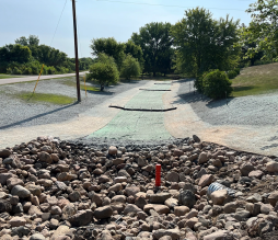
The first phase of construction was in the summer of 2023. Since this was a large project to construct, and time management was important to get the job complete by the end of 2023, the construction process began with the installation of the underground tile in the middle of June after the corn had been planted. Since there was crop damage (photo 5) during the beginning of construction, All Acres for Our Water (AAFOW) was willing to provide additional funding to cover the amount of crop damage during tile installation. During this time, the grassed waterway in the lower part of the watershed was constructed and seeded to make sure vegetation was present going into winter for the next spring runoff events.
The second phase of construction took place after the corn crop was harvested. This phase of installation included the construction of six water and sediment control basins and one grade stabilization structure. Each one of these practices includes the removal of all topsoil, placing the proper kind of fill to meet compaction requirements to the designed elevations, and then to replace the topsoil to provide a proper seedbed for next year’s planting. Each water and sediment control basin and grade stabilization structure has a tile inlet with a properly sized orifice to make sure that pooled water draws down in a certain amount of time to not damage crops, but to also maximize the water quality and sediment reduction.
Components:
Dual Wall Wipes
Erosion Control Blanket (curlex type 2)
Turf Reinforcement Mat
Hicken Bottom Inlets
Native Grass Seed Mix
Culvert Installation
Benefits:
Increased Water Quality
Reduced Sediment Loss
Reduced Gully Erosion
Pollution Reduction Estimates:
Sediment: 1,698 tons/yr.
Phosphorus: 1,218 lbs./yr.
Partners on this project included all of the landowners involved, All Acres for Our Water, USDA Natural Resource Conservation Service, and the Stearns Conservation District.

Project Gallery